Note: All photos can be seen at higher resolution by downloading. In most browsers this is accomplished by right-clicking on the photo and then selecting an option such as "Save Picture As" (Windows) or "Save Image to" (Mac OS X). With a single button mouse, control-clicking (holding the CTRL key while clicking) usually is equivalent.
Usually the Sierras don't have very good lift and I soar on the mountain ranges to their east. This is because the Sierras catch most of the precipitation from the prevailing westerly winds, so the sun's heating goes more into evaporating water from the ground and vegetation, and less into creating the high ground temperatures that cause thermals. After the westerly winds drop their moisture on the Sierras there is little left for the mountain ranges to the east, so their barren slopes get really hot in the summer, creating strong thermals.
While it is a rare treat, soaring the Sierras is truly awesome. Their higher moisture content reduces thermal activity, but also creates unbelievably beautiful scenery: forests, meadows, lakes, and small glaciers capping some of the higher peaks year-round.
This day was even better than usual for soaring the Sierras since I was able to cross at Yosemite without using my engine. Crossing as a glider near Tahoe is much easier since the Sierras there are lower and narrower with passes around 7,300 feet, most peaks under 10,000, and at most a few miles to traverse before you have a clear shot at a safety airport to the west. But here at Yosemite, Tioga Pass is 10,000 feet, many peaks exceed 12,000, and the "high country" is 20 miles wide. Another impediment to a glider crossing at Yosemite is the prevailing westerly winds. These usually produce strong sink on the east (lee) side of the Sierras. But some days, the winds are light, the thermals are high, I can comfortably execute a glider crossing at Yosemite, and I feel truly blessed. I hope some of that feeling can be communicated on this page.
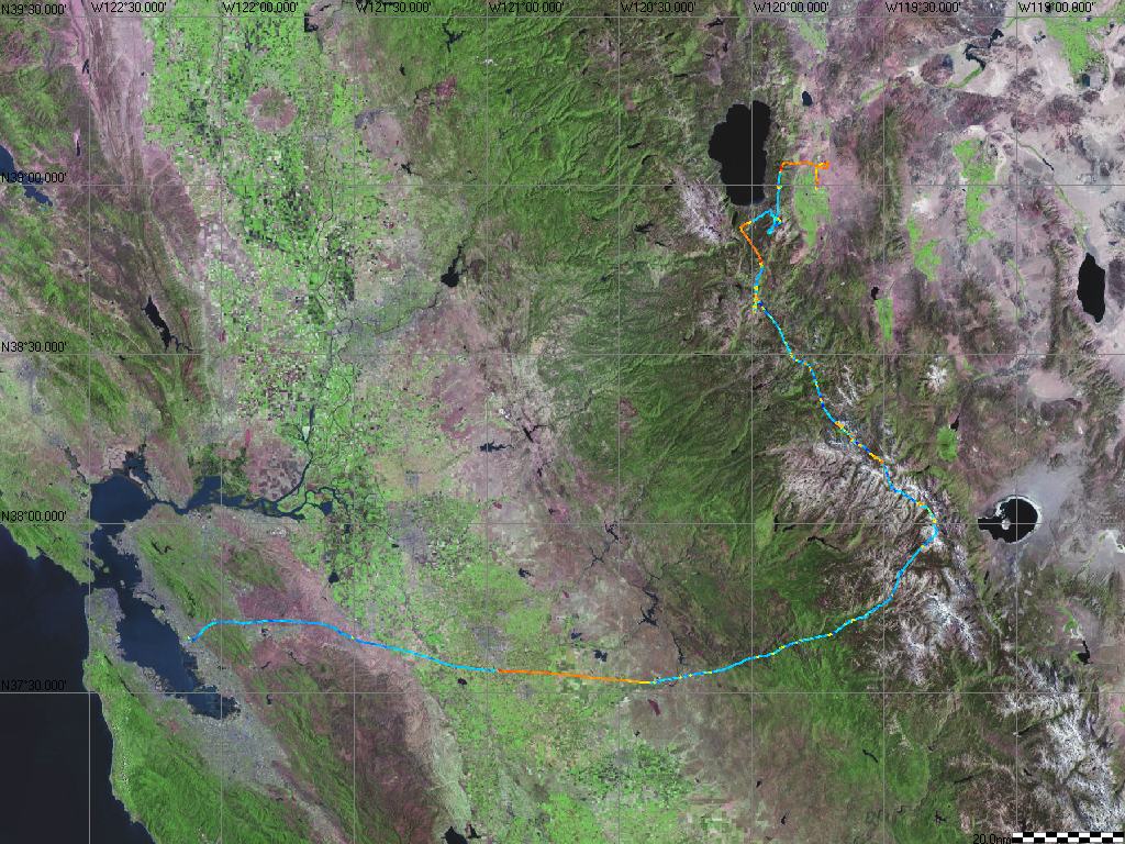
The map below shows the entire route of flight from Minden, NV to Hayward, CA, superimposed on satellite views of the Earth. Minden is just east of Lake Tahoe, near the top of the map. Hayward is on the east side of San Francisco Bay, near the lower left corner. Mono Lake and Yosemite are near the lower right corner, with Paoha Island clearly visible in the middle of Mono Lake even in this 200 nm (230 statute miles) wide map.
The flight trace was obtained from a data logger installed in the glider which records my position and altitude every twelve seconds. A software package SeeYou provides numerous ways to analyze the flight. Here, the flight trace is color coded to show the rate of climb or sink. Hotter colors (yellow, orange and red) indicate faster climb and cooler colors (deeper shades of blue) indicate faster sink. The three portions of solid orange (climb) correspond to engine runs: first on takeoff from Minden; a second short engine run just south of Lake Tahoe which got me to good lift; and a final sixteen minute engine run over the Central Valley which provided a generous safety margin for gliding the rest of the way to Hayward. The flight lasted 3.9 hours and required only 0.6 engine hours in total.
Short colored blips indicating climb are thermals or other localized lift, and several longer climbs (other than the engine runs) were under cloud streets. Even though the regions of climb are much shorter than the areas of sink, I was able to maintain altitude by slowing down or circling in the lift and speeding up in the sink. Note the almost total absence of lift west of the Sierras.
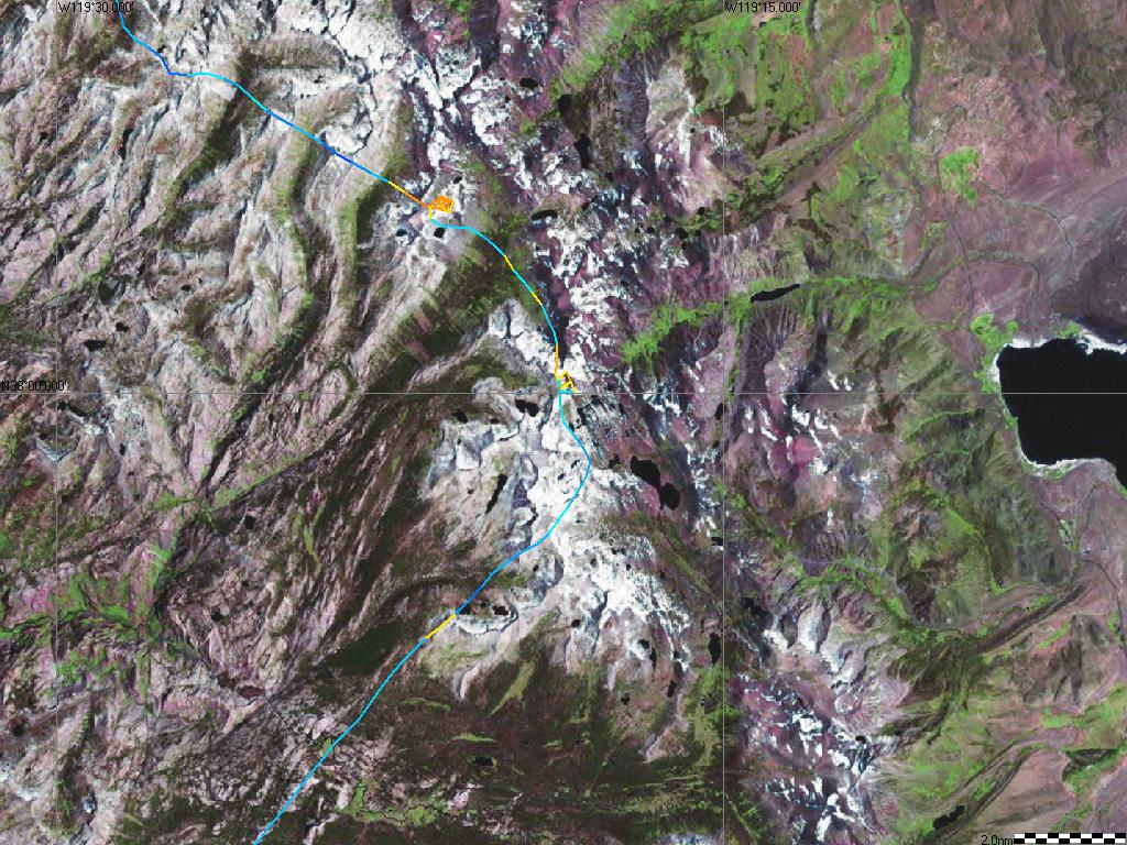
The first four photos below were taken while circling at 15,000 feet in the thermal indicated by the yellow blip closest to Mono Lake. This thermal was located about 10 miles north of Tioga Pass (the east entrance to Yosemite National Park) and is marked along with several other landmarks in the map below which has a 50 nm width. (The Picture-Thermal is the yellow blip just to the left of the P of its label. Saddlebag Lake is just above the L of its label. Tenaya Lake is just to the left of its label and my flight trace. Yosemite Valley is the green area just below its label. Tuolumne Meadows is the horizontal green area above the Tenaya Lake label, and Lyell Canyon is the almost vertical green area to the right of the Tenaya Lake label. Most of these landmarks will figure in later photos.) The satellite images were taken earlier in the year so they show more snow than is present in my photos.
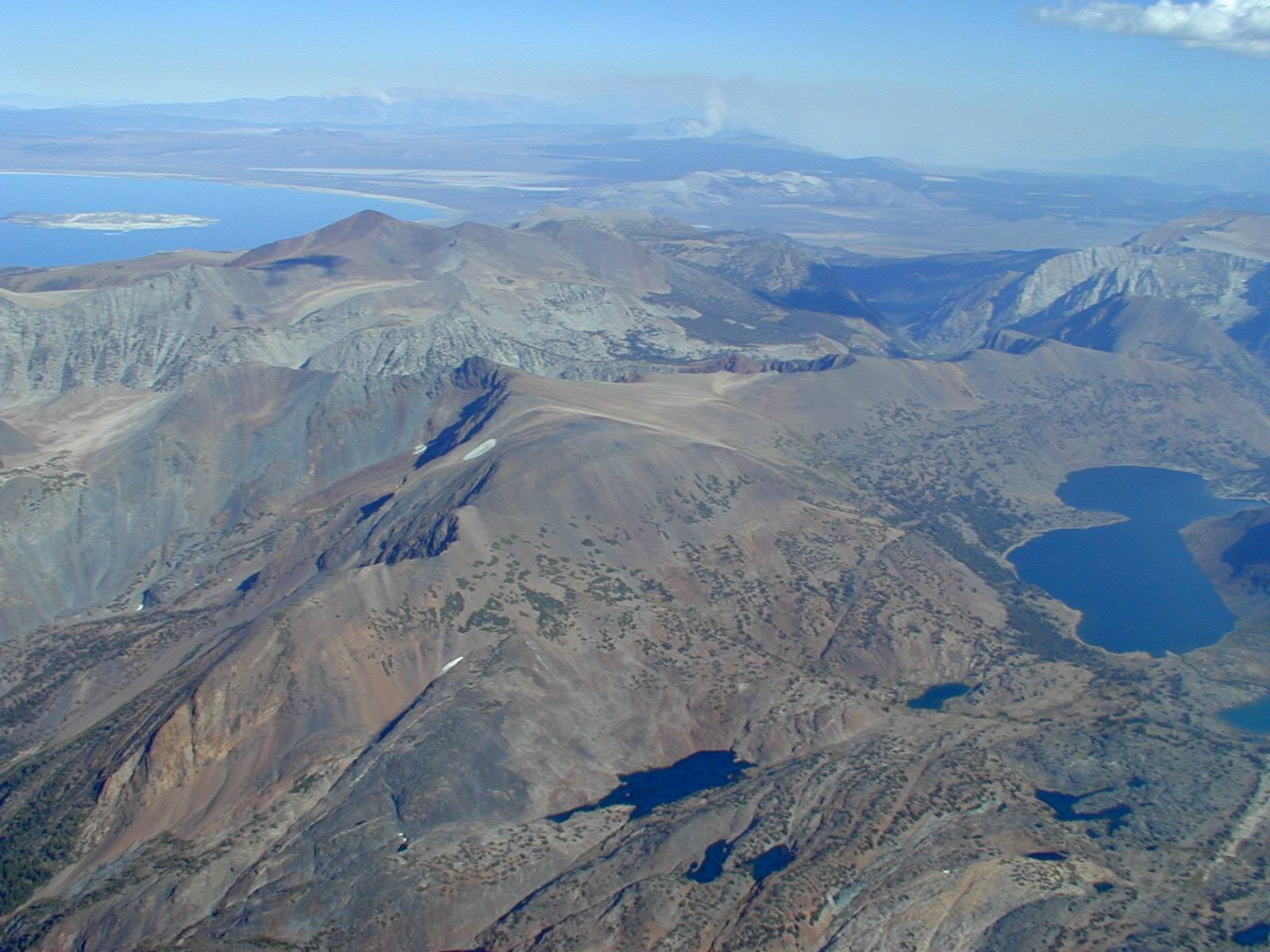
The photo below was taken looking southeast from the Picture-Thermal. Saddlebag Lake is at right center, shaped like two saddlebags, and Mono Lake is the large lake at the top left with Paoha Island in its center. Tioga Peak is the rounded mountain just beyond Saddlebag Lake at the right edge of the picture. Mt. Dana, at 13,053 feet the second tallest peak in the park, is behind Tioga Peak, with Tioga Pass running between them. Of interest mostly to those who have hiked the area: Z Lake (obvious by its backwards Z shape) is near the bottom right corner; Hummingbird Lake is slightly to the left of a line connecting Z and Saddlebag Lakes; Twin Lakes (not the same as the ones near Bridgeport - these are much smaller) are at the bottom center; and Odell Lake (the longer one) is just above Twin Lakes.
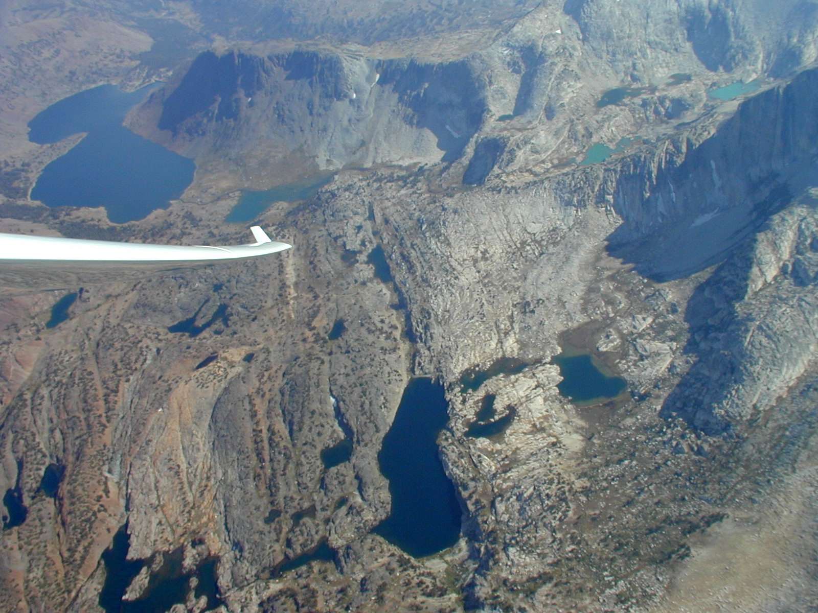
The photo below was taken looking SW from the Picture-Thermal. The center of the photo shows Upper McCabe Lake, shaped like Saddlebag Lake but smaller. Two even smaller McCabe Lakes are above and to its right. (The one in the upper right corner of the photo is only partially visible and hard to see.) North Peak (12,250’) is in the upper left corner of photo. The tip of Roosevelt Lake is at the top center of photo. (If interested in finding these places on the maps: Upper McCabe Lake is barely discernable in the 50 nm map just to the left and slightly below the Picture-Thermal, but is easily seen in the 20 nm map which follows this photo. Roosevelt Lake, the long, thin lake just above the d's of Saddlebag in the 50 nm map, is also much more visible in the 20 nm map, where it is about as far to the left of my flight trace as Saddlebag Lake is to its right, and at the same height in the photo.)
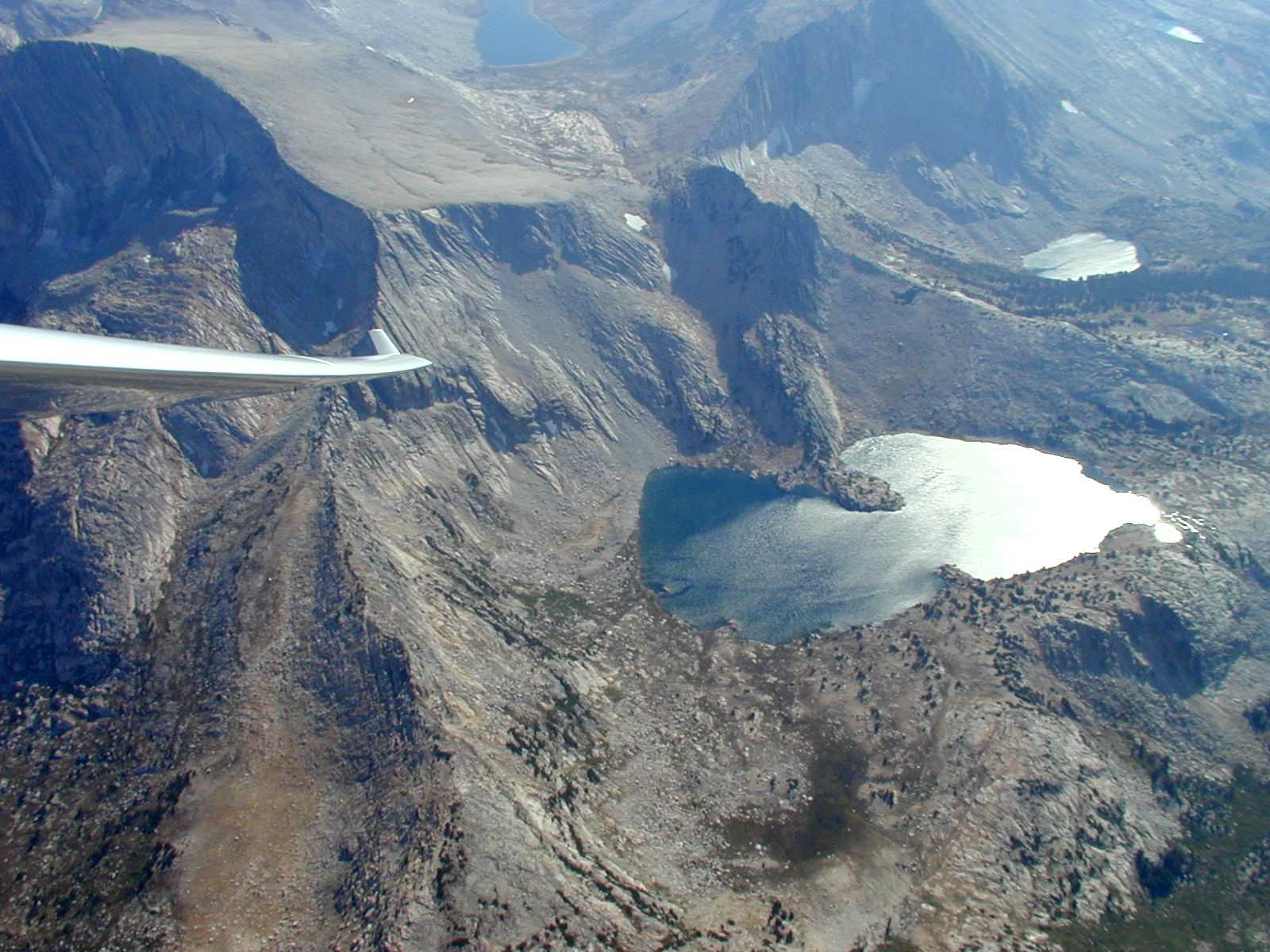
The photo below was taken looking SSE from the Picture-Thermal. Saddlebag Lake is now in the upper left corner. Conness Lakes are in the upper right and show glacial milk coloring since they are fed by Conness Glacier (not visible). Of interest mostly to those who have hiked the area: Greenstone Lake is just above my winglet. Z and Hummingbird Lakes are just below my wing. Steelhead Lake is the largest lake in the lower center, with Wasco Lake just above it, looking almost like a wide stream. Potter, Towser and Cascade Lakes are to the right of Steelhead Lake. Cascade is the larger and furthest of the three. Towser looks like an upside down mushroom, but seems to have dried out where the stem meets the cap. Potter is a thin lake, almost connecting the southern tips of Cascade and Steelhead Lakes.
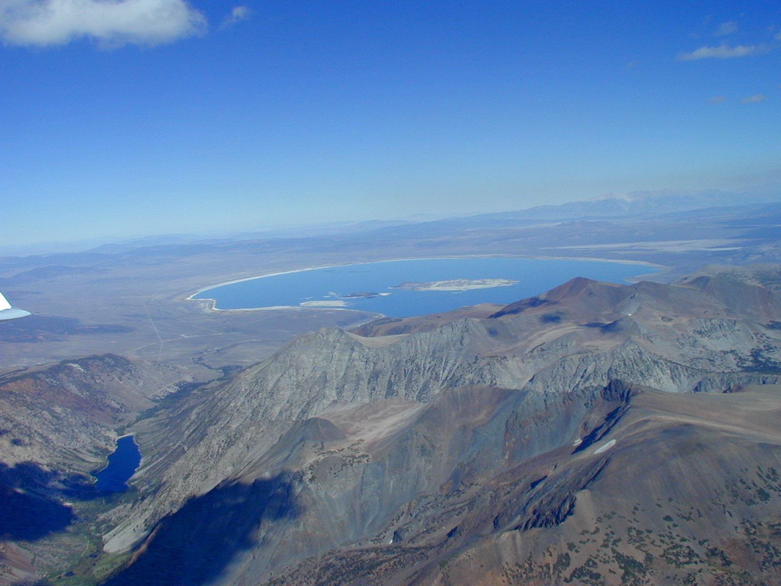
In the last photo taken from the Picture-Thermal shown below, we are looking east and see Mono Lake with Lundy Canyon and Lundy Lake on the left side of the photo. In the 50 nm map Lundy Lake is above the T of Picture-Thermal and is more easily seen in the 20 nm map.
The picture below is a 3D view created by SeeYou which shows my glider just after leaving the Picture-Thermal. Lake Tahoe is barely visible in the distance, at the top of the picture and just under the [337o], indicating the compass heading of the view. Saddlebag Lake is at the bottom of the picture slightly to the right of center. The early part of the flight trace is not shown.
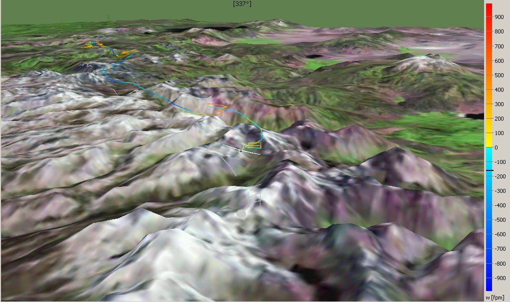
Climbs in several thermals can be seen. The Picture-Thermal provided almost no altitude gain and was either very weak or I was not well centered due to the distraction of taking pictures. The difference in thermal strength can also be seen in the 2D maps. The Picture-Taking thermal is yellow and the preceding, stronger thermal (with an obvious altitude gain seen above) is a hotter orange color. The 3D picture has a scale on the right hand side showing the color key for climb and sink rates in feet/min. In addition to the color coded trace showing the glider's position through the air, SeeYou shows a gray trace for the glider's position over the ground.
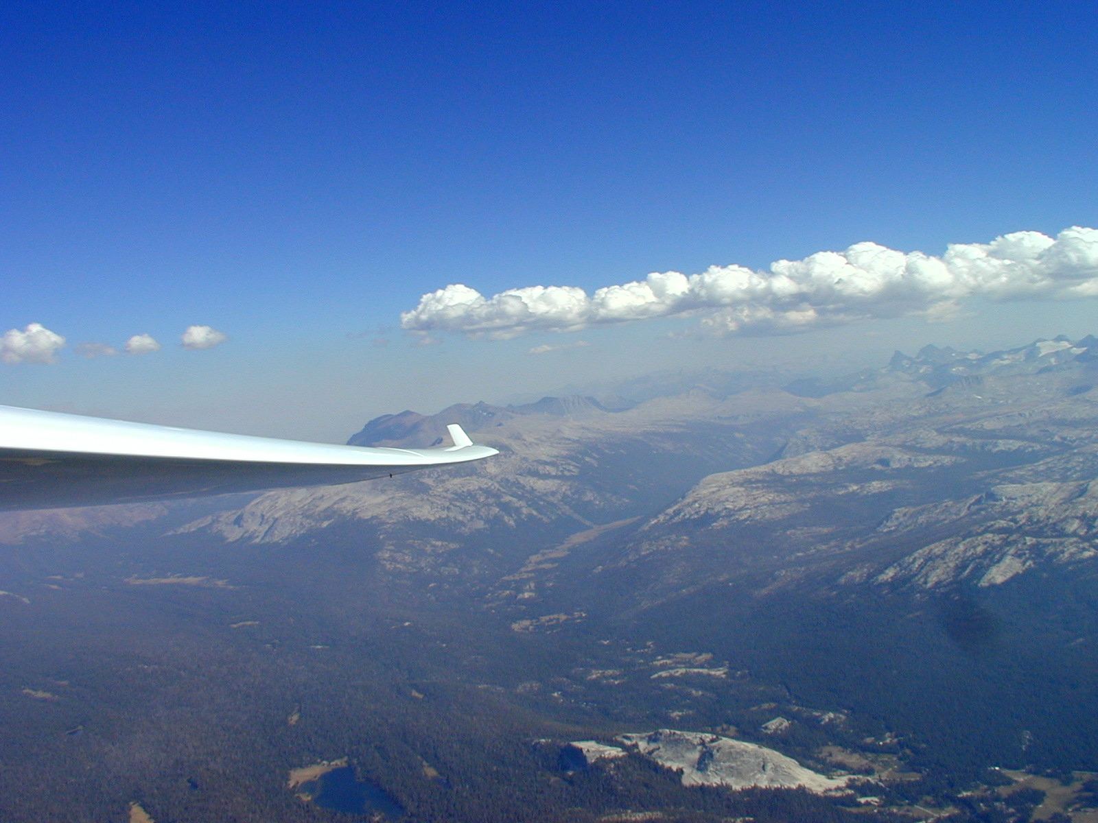
The photo below was taken five minutes after leaving the Picture-Thermal, flying southwest at approximately 14,000 feet and looking southeast. Note the well formed cloud street -- unfortunately not on my route of flight. Lyell Canyon and the Lyell Fork of the Tuolumne River are in front of my wing and run up the picture for some distance. They are bounded by Kuna Crest on the left (partly covered by my wing) and the Cathedral Range on the right, and flow into Tuolumne Meadows and the main fork of the Tuolumne River at the lower right portion of the photo. If you have driven the Tioga Pass Road (California Route 120) through Yosemite, you have probably seen Lembert Dome, located near the bottom edge of the photo and slightly right of center. Dog Lake is to the left of Lembert Dome.
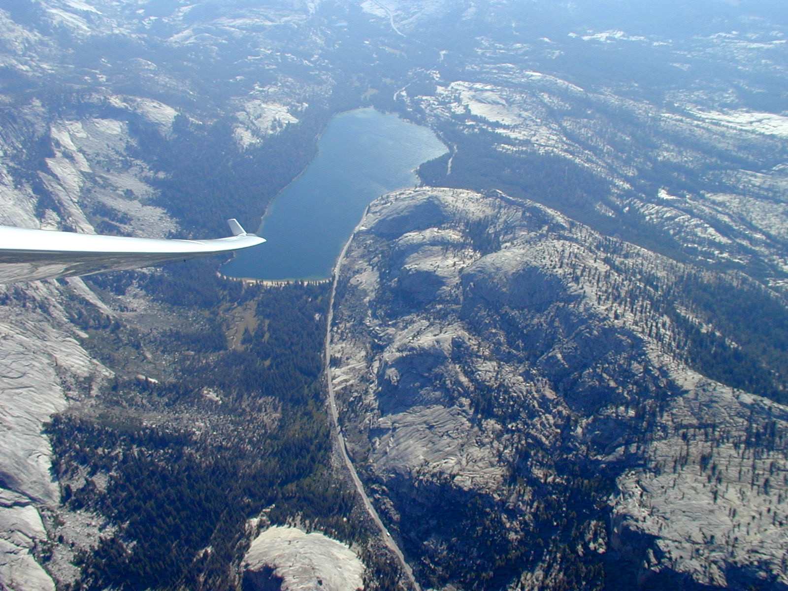
Below is the last of this series of photos. Taken midway through Yosemite and looking west, it shows Tenaya Lake and Tioga Pass Road. Having crossed the high country, I now had a clear view of my escape route to Mariposa airport. If I had been lower, I could have followed Tenaya Canyon, which starts at the far end of Tenaya Lake, to Yosemite Valley and then followed the Merced River to Mariposa. But, since my crossing up to this point had not burned up too much altitude, I was able to choose a route that took me more directly to Hayward. As can be seen on the 50 nm map, I even felt comfortable enough to do a few circles when there was no lift, just to enjoy the views. These show up as blue circles on the flight trace.
Return to Soaring Photo Links Page
Return to Martin Hellman's Home Page